EQUIPMENT & ACCESSORIES
Given the advancement of technology of this age, Digital Horizon Company Limited has maintained pace with changes in technology. Thus in our stock are some of the latest cutting-edge technologies especially in digital technology and offshore positioning.
Shown below are some of our equipment which are similarly available for hire
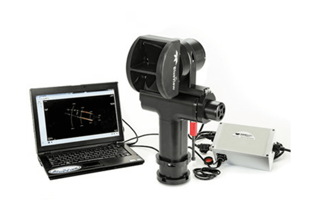
3D SCANNING SONAR
The BlueView BV5000 MK2 3D mechanical scanning sonar creates high resolution imagery of underwater areas, structures, and objects. With the touch of a button, the sonar creates 3D point clouds of an underwater scene with minimal training required. This proven, versatile, and lightweight unit is easily installed on subsea vehicles such as ROVs and AUVs, operating down to a maximum depth of 1000m. It can also be deployed landside such as dockside, bridges or on surface vessels when fixed to the optional tripod. The scanning sonar head and integrated mechanical pan and tilt mechanism generates both sector scans and spherical scan data. The BV5000 MK2’s 3D laser-like scanning capabilities and seamless integration with traditional laser scan imagery produce great results even in low and zero visibility conditions.
Applications:
- 3D site survey
- 3D structure inspection
- Rig decommissioning
- Bridge inspections
- Underwater metrology
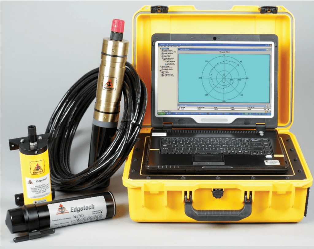
ULTRA SHORT BASELINE (USBL)
TRACKPOINT PORTABLE
IPS (INTEGRATED POSITIONING SYSTEM)
MULTI BEACONS
HYDROPHONE
Applications:
- ROV tracking including support for Doppler Velocity Log (DVL) based navigation
- Manned Submersible Tracking including DVL based navigation
- UUV/AUV tracking including Acoustic modem support
- Survey / Towfish Tracking • Initial site Location
- Pipeline Survey
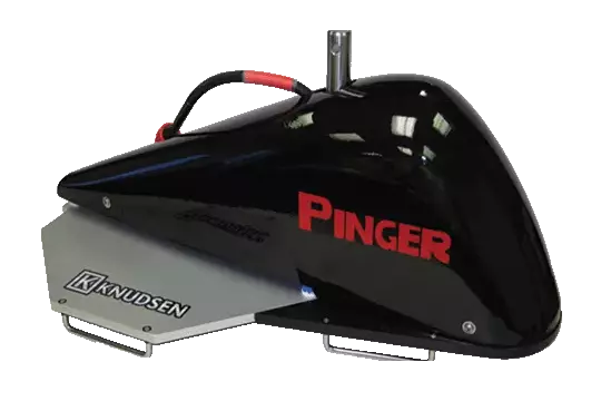
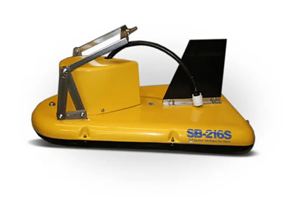
Pinger Sub Bottom Profiler
Pinger is designed specifically for shallow water sub bottom profiling (as shallow as 4m and up to 300m in ideal conditions) and is intended for a simple over the side pole mount installation. The Pinger Wet End includes two separate interchangeable projectors – a low frequency 3.5 kHz projector for hard packed sand bottom and a 15 kHz projector for soft mud sediment sonar profiling – plus a broadband hydrophone receive array. A 200 kHz transducer is also included which provides a reference point as to where the bottom begins. This allows a wide variety of practical applications, including geophysical sediment research, harbour shoreline construction, and hazardous pond pollution monitoring.
Number of Channels: 2
Frequency Range (Channel 1): 3.5 kHz/15 kHz
Frequency Range (Channel 2): 210 kHz
Max Depth: 300m
The Pinger Dry End is a portable, black box system which plugs into the user’s computer via a USB cable connection. The system is controlled through the KNUDSEN SounderSuite Windows application software which is supplied with the unit. The user will be able to view depth records in real time and record high resolution data onto their computer hard drive for archival and post processing.
The Pinger Sub Bottom Profiler is also capable of operating in Bathy mode. The Dry End system is equipped with a toggle switch, allowing operators to select between receiving on the large aperture array or receiving with the projecting transducer (additional transducers sold separately). If you have a requirement for a shallow water sub bottom profiler, and need a standard bathymetric system for the same vessel, the Pinger is a good option to consider for your geophysical exploration.
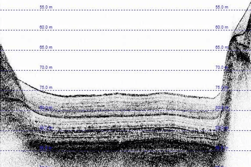
EdgeTech 3200 FS Sub-Bottom Profiling System
The EdgeTech 3200 Sub-bottom Profi ling System is a wideband Frequency Modulated (FM) sub-bottom profi ler utilizing EdgeTech’s proprietary Full Spectrum CHIRP technology.
The 3200 generates high resolution images of the sub-bottom stratigraphy in oceans, lakes, and rivers and provides penetration of up to 200m.
The 3200 comes available with a choice of three stable, low drag towfish that operate at different frequencies and can be used at depths of up to 300m. The selection of towfish depends on the sub-bottom characteristics as well as the resolution and penetration requirements.
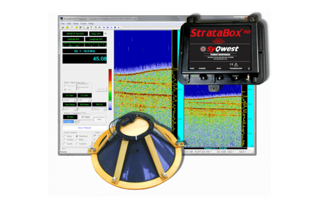
SyQwest Stratabox Sub-bottom profiler
The StrataBox HD TM is a portable high-resolution marine sediment imaging instrument capable of delivering 6cm of marine sediment strata resolution with bottom penetration of up to 40 meters. It is designed exclusively for inshore and coastal geophysical marine survey up to 150 meters of water depth.
KONGSBERG MESOTECH MS1000
- 3D profiling possible with rotating device
- Track Plotter module allows user to plot scanned area, geo-reference targets, and create GeoTIFFs
- Target tracking feature
- Simultaneous multi-head operation capability
- Coordinate system support – includes support for local coordinate systems of different countries and territories
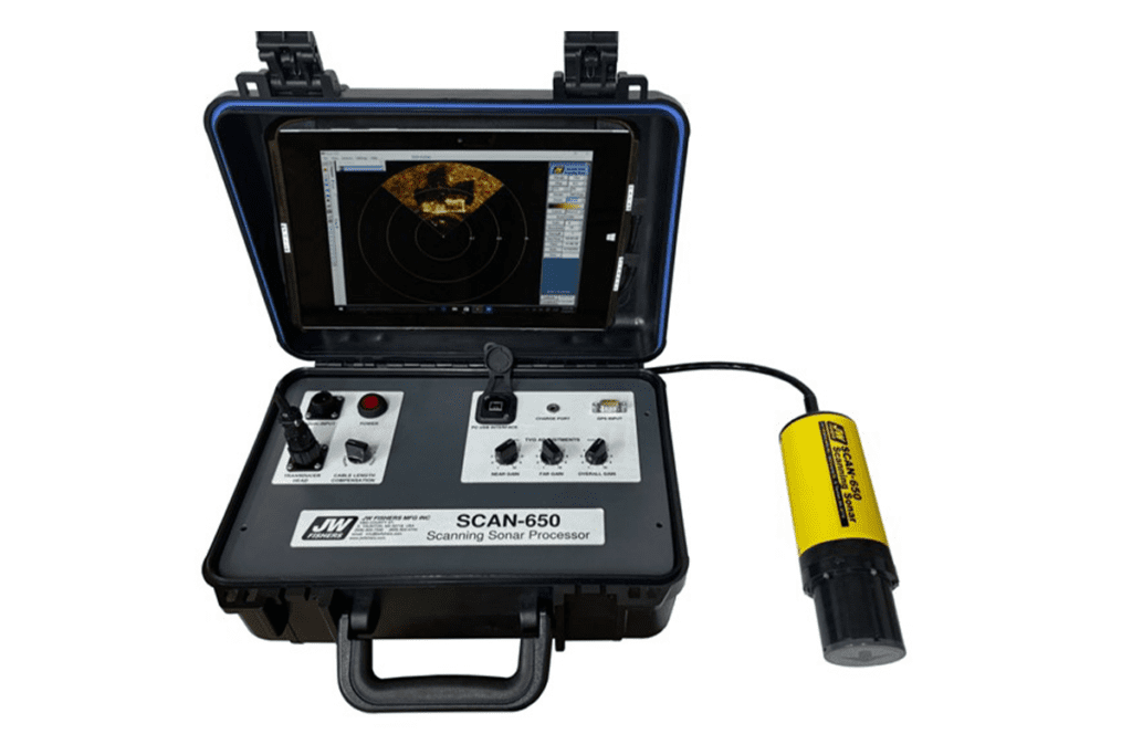
JW FISHER SCAN-650 Sector Scanning Sonar
- High Resolution imagery
- Fast scan even on 1/2 degree steps
- 1/2. 1/ 1 1/2, or 2 Degree Steps
- 360 degree continuous sweep or any portion of 360 Degree
- Target sizing
- 256 available colors
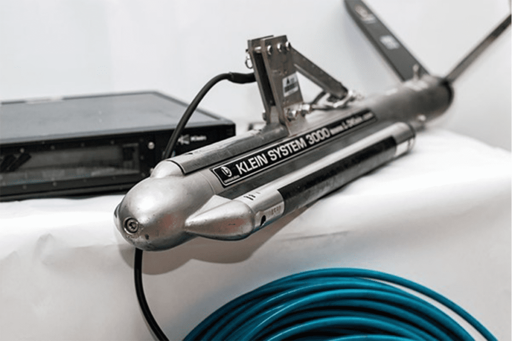
Klien Marine System 3000H
Based on the proven System 3000, the 3000H offers superior resolution for those who require advanced levels of target classification. By using high frequency 445 and 900 kHz arrays, superior along track resolution is achieved as the operator views stunning imagery in real time. The same rugged construction that Klein is known for has been designed into the 3000H guaranteeing success in the harshest marine environments. Depth rated to 200 m, this system offers surveyors the flexibility of being able to operate in shallow or deep water.
C-MAX CM2 DIGITAL SIDE SCAN SONAR
The CM2 towfish incorporates dual frequency operation, with a choice of two configurations, DF (100/325kHz) and EDF (325/780kHz).
For general survey tasks DF towfish are often the most useful. In 100kHz mode the search swath is up to 1000m wide, useful for searching for larger objects such as wrecks or freight containers. In 325kHz mode it is usually possible to distinguish such objects as mooring ropes, anchor chain, anchors, scour marks, pilings, crab pots, rocks (down to the size of a briefcase or less), as well as differences in seabed texture.
EDF towfish offer the highest resolution. Like the DF towfish they offer 325kHz operation out to 150m. The EDF’s 780kHz frequency gives the most detailed images, very useful for positively identifying an object first located at 325kHz.
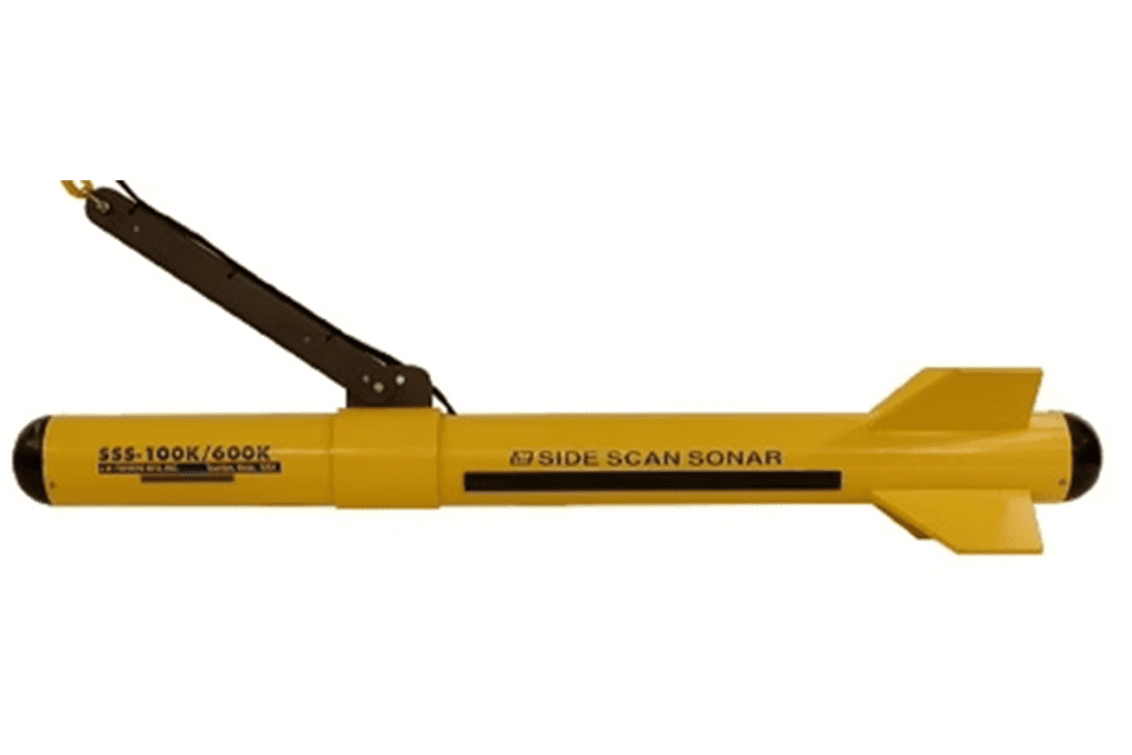
JW FISHER DUAL FREQUENCY SIDE SCAN SONAR 100K/600K
JW fishers underwater dual frequency 100k and 600k side scan sonar system provide a visual image of vast areas of the ocean floor. This unit is an effective device for use in checking on the status of buried pipelines and cables. This unit is popular for military, dredging operations, fisheries and for large scale environmental studies. Fishers offer three different frequency side scan systems; the SSS-100K, the SSS-600K, and the dual frequency system SSS-100K/600K. The SSS-600K has very high resolution over ranges of up to 200 feet (400 foot swath). This system is ideally suited to search for small or soft targets. Applications for this system include: searches for old wooden wrecks, scattered debris fields, ghost nets, logs, drowning victims, mine countermeasures (MCM) by the military, and a variety of other targets. It can also locate larger targets such as sunken vessels at ranges of up to 200 feet. The SSS-600K is in use by law enforcement agencies, dive rescue groups, and military units worldwide.
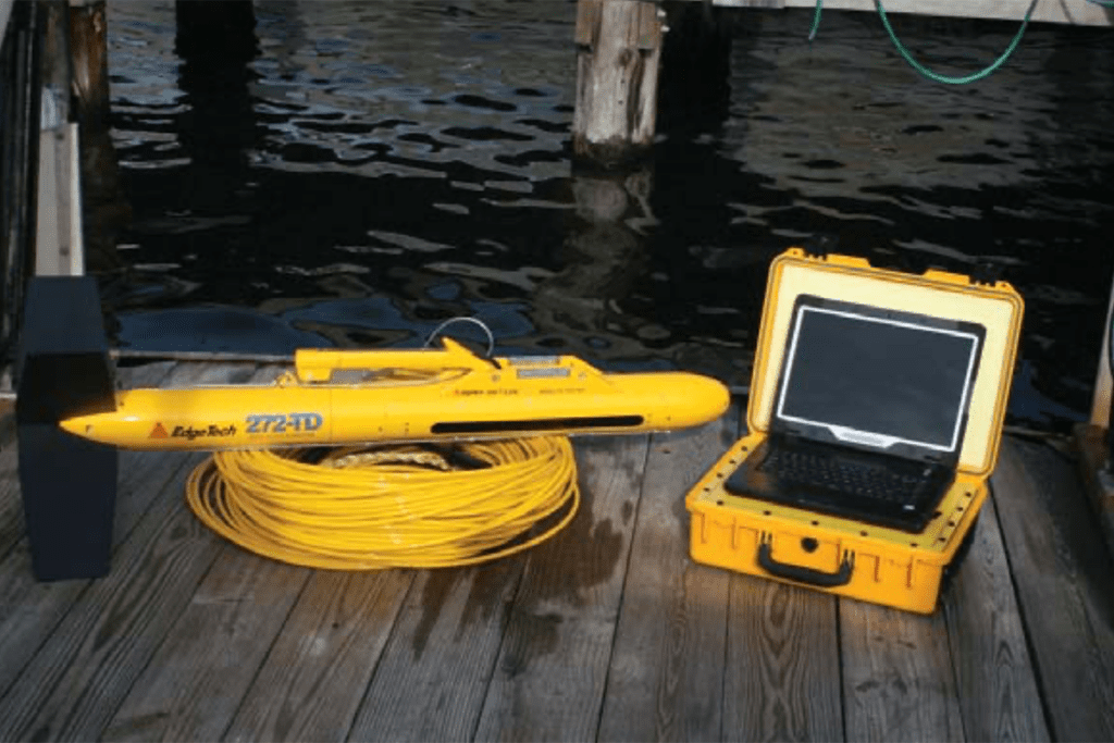
EDGETECH 560P TOPSIDE AND MODEL 272-TD DUAL-FREQUENCY TOW FISH
The 272-TD towfish is lightweight enough so that it can be deployed by one person which makes this system ideal for use from smaller boats or ones where an onboard handling system is not available. The towfish is equipped as standard with EdgeTech’s patented Saf-T-Link recovery system which will prevent the loss of the towfish if it becomes snagged on an obstacle during towing.
Frequency: 100/500 kHz
Max depth rating: 1,000m
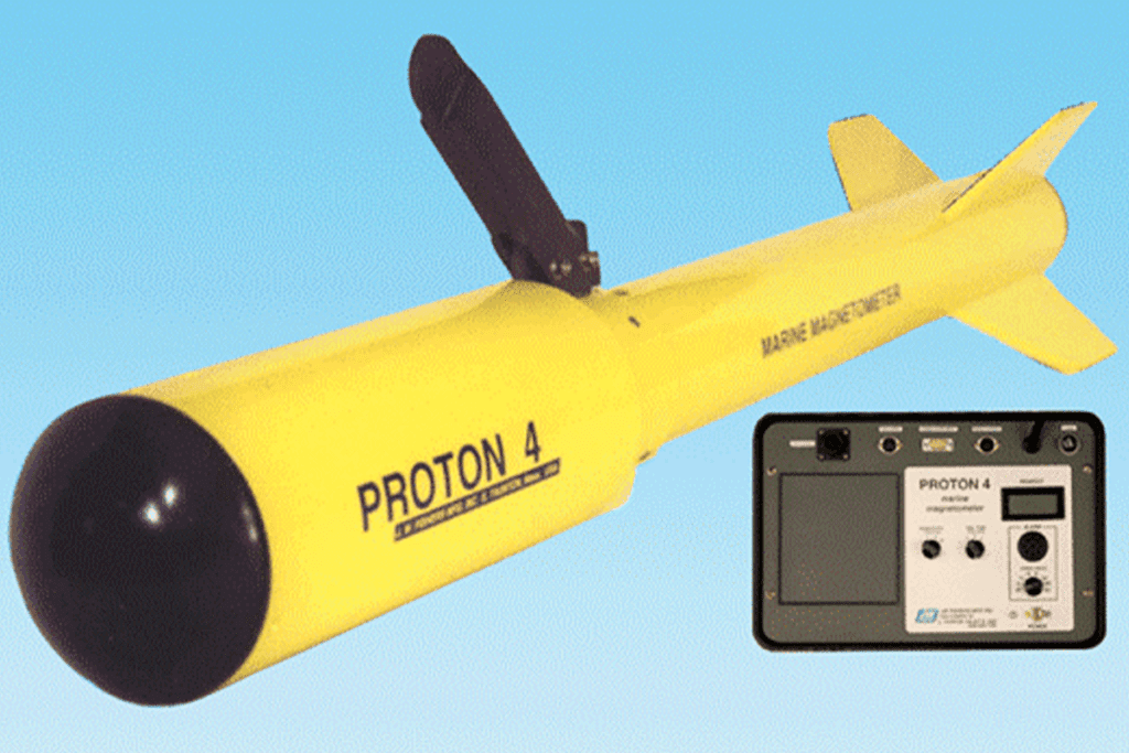
JW FISHERS PROTON 4 UNDERWATER MAGNETOMETER
The PROTON 4 is the fourth generation magnetometer from JW Fishers. The Proton mag is the “work horse” of the commercial salvage industry and the preferred choice of many professional wreck hunters. It can locate a variety of iron and steel targets including sunken vessels, anchors, chains, cannons, moorings, pipelines, submerged vehicles, and lost equipment. The PROTON 4 is a top performing microprocessor driven marine magnetometer detection system with one gamma sensitivity. It features a triaxial noise-cancelling sensor that allows omnidirectional towing without heading error or dead zone. The system is fully digitized and displays it’s output on an easy to read 5 digit LCD that is backlit for night operations. An alarm informs the operator when the readout changes, and Tracker software allows the operator to see the path of the boat as it moves over the search area, ensuring no piece is missed. The magnetometer readouts and position coordinates are displayed in an easy to read format on the computer, and all the data can be saved for future reference. The towfish has excellent hydrodynamic characteristics, moving smoothly through the water at tow speeds up to 10 knots.
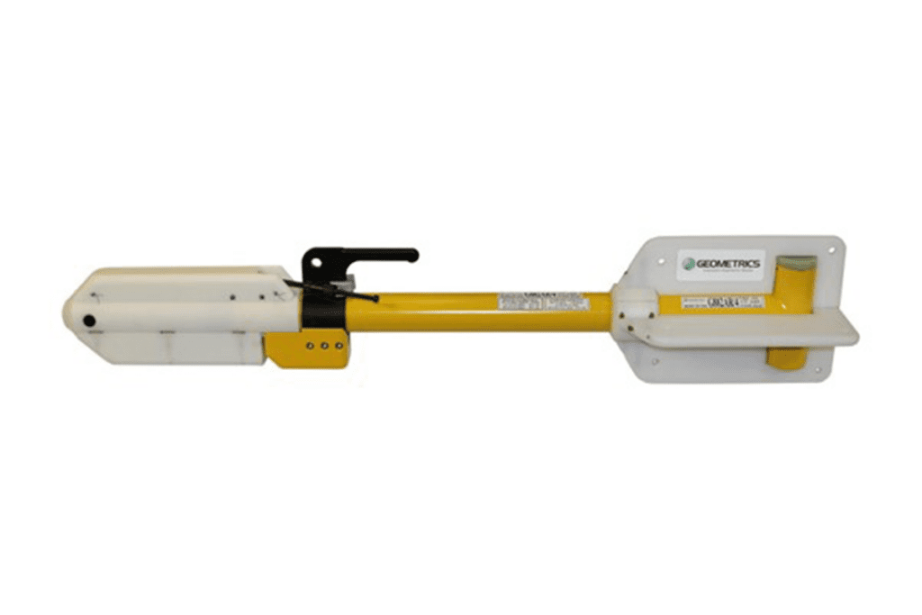
Geometrics G-882 Marine Magnetometer
- Cesium Vapor High Performance: Highest detection range and high probability of detecting all sized ferrous targets.
- Streamlined Design for Tow Safety: Low probability of fouling in fishing lines or rocks. Rugged fiber-wound fiberglass housing.
- Sample at up to 20Hz: Unparalleled data density while also covering larger areas per day.
- Sensor can be Rotated for Optimal Signal: Can be used worldwide.
- Easy Portability and Handling: No winch required. Built-in easy-carry handle. Operable by a single man; only 44 lb. with 200 ft. cable.
- Internal CM-221 Mini-Counter: This little counter provides multi-sensor sync and data concatenation, allowing the user to combine multiple systems for increased coverage.
- Export Version Available: Use anywhere in the world without need for an export license (except embargoed countries).
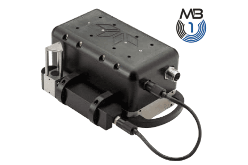
Teledyne Odom Hydrographic MB1 Multibeam Echo Sounder
Using both amplitude and phase bottom detection, the MB1 is capable of sounding a swath of up to 120° in over 120m water depth and up to 240m at nadir. With 24 bit raw data and a dedicated projector, both raw water column and seabed data can be collected within the con- troller software. The new and improved Real Time Appliance (RTA) improves time synchronization on all of the sensors nec- essary for surveying down to 0.1ms. New options include a fully integrated GPS heading system built into the RTA and a TSS motion sensor built into the sonar head. Teledyne Impulse Titan® Series connectors are used for quick dependable data and power connection.
- Operating frequency from 200 – 460 kHz
- Swath coverage from 10° to 140°
- Up to 256 beams
- Phase and amplitude bottom detection
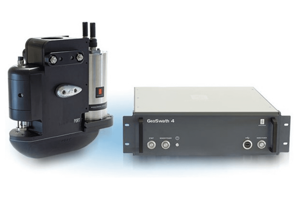
KONGSBERG GeoSwath 4
GeoSwath 4 offers industry-leading simultaneous swath bathymetry and side scan sonar mapping for shallow waters. The turnkey solution comprises a dual transducer head with versatile mounting options. The deck unit contains the complete sonar electronics together with a high-spec PC running the latest dedicated GS4 version of the software. The software provides full acquisition, calibration, and data processing capabilities for producing the final bathymetry map and side scan mosaic.
The GeoSwath 4R also includes a dual transducer head with a 240º field of view from nadir to waterline, enabling bottom coverage of up to twelve times the water depth. Transducers have a versatile range of mounting options and are available in 125, 250 or 500 kHz versions, each varying in depth and data resolution to optimise performance for the individual survey task.
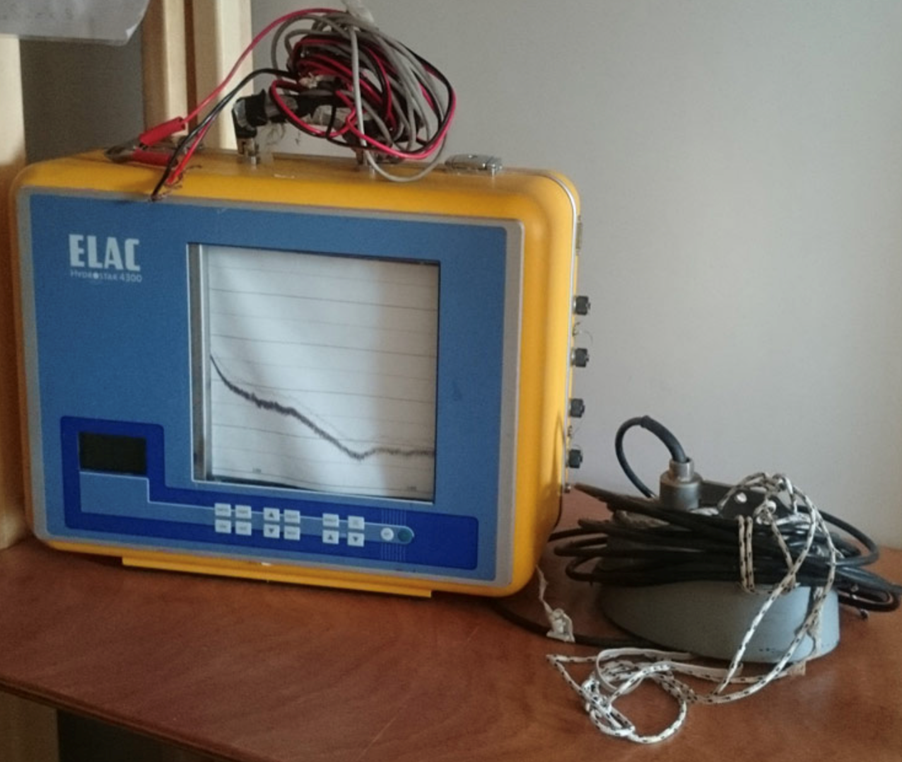
Elac HydroStar 4300
The HydroStar 4300 is a portable dual-frequency single beam echo sounder that provides reliable depth measurements for small survey boats. It operates at 30 kHz and 200 kHz frequencies with a maximum depth of 80 meters and 1000 meters, respectively. The echo sounder offers standard interfaces, integrated heave compensation, and supports automatic chart annotation.
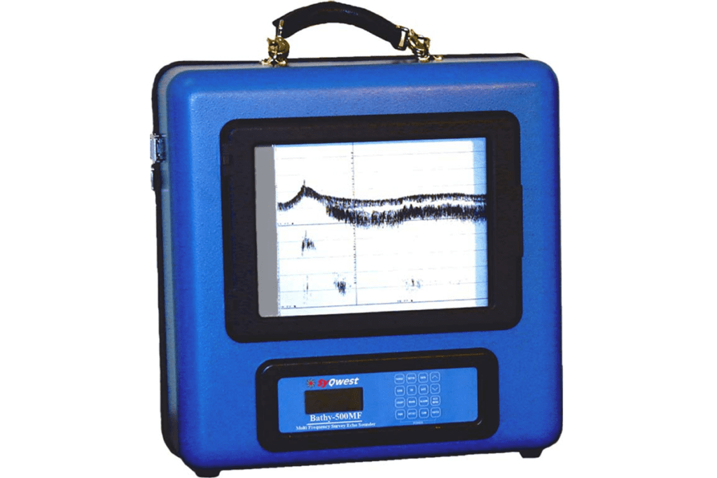
Bathy- 5OOMF Multifrequency- survey echo sounder
The Bathy-500MF is a state-of-the-art electronic survey instrument used to generate precision chart recordings and digital data output.Low power consumption, portability, ease of use, rugged construction, and built-in communication interfaces for navigation/data logging devices make the Bathy-500MF ideal for shipboard use. The instrument is housed within a splash-proof, aluminum enclosure.
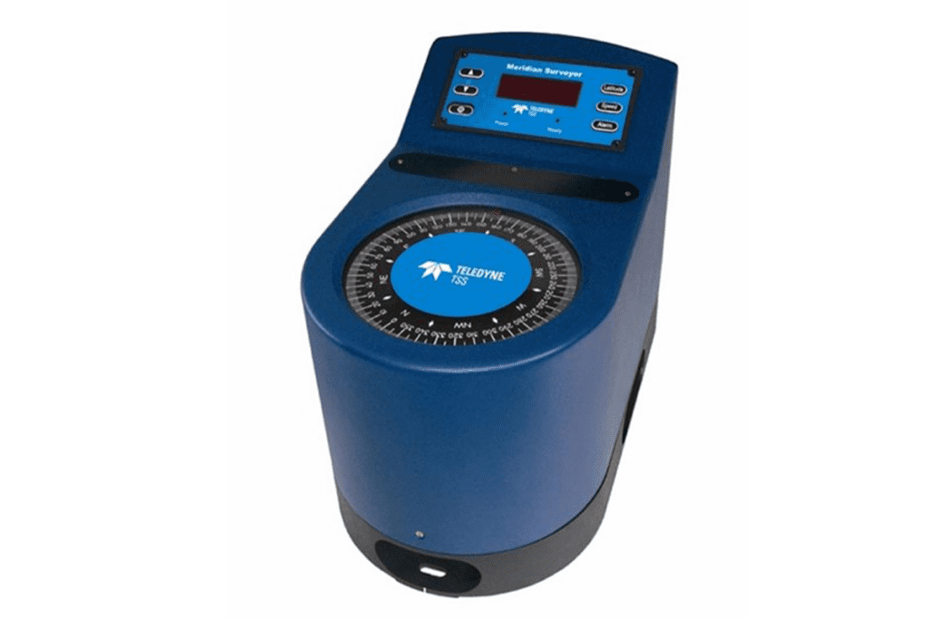
SG BROWN MERIDIAN SURVEYOR GYROCOMPASS
- Innovative chassis design incorporating state-of-the- art digital electronics for improved reliability.
- Dynamic heading accuracy of ±0.2°
- Static heading accuracy of 0.05°
- < 40 minutes settling time
Teledyne Saturn 30 AHRS
- Heading, pitch, roll, heave and velocity outputs
- 3° sec lat accuracy
- Maintenance free with high MTBF
- IMO approved and WheelMark certified
- AHRS to INS upgrade functionality
- Robust aluminium construction, IP31-rated
- Fast alignment giving less down time, and more operational time
- Low power consumption compared to RLG alternatives
- Simple configuration and set up via TSS common embedded browser
- Based on the dependable Teledyne TSS FOG IMU
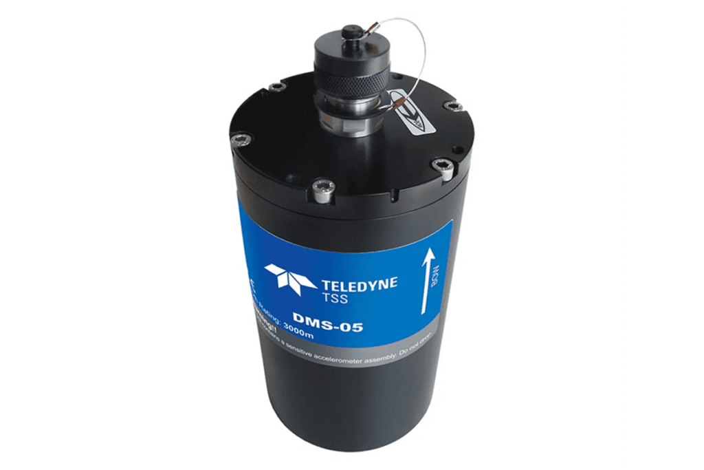
TELEDYNE TSS DMS-05
- Dynamic roll and pitch accuracy 0.03deg RMS (+/- 5deg)
- Dynamic roll and pitch accuracy 0.05deg RMS (+/- 30deg)
- Heave accuray 5cm or 5%
- Solid state solution available in surface or subsea housings
- High dynamic accuracy during vessel turns
- Independently configurable outputs
- Intuitive control software with user-configurable outputs
- Real-time digital and analogue outputs
- Low power, cost-effective solution
- Survey to Class 1 IHO standard
- High reliability
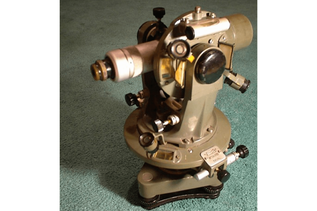
THEODOLITE
A precision optical instrument used primarily in surveying and engineering to measure angles in the horizontal and vertical planes.
- Components: Telescope, horizontal circle, vertical circle, levelling mechanisms,
- Applications: land surveying, construction alignment, tunnel and bridge engineering, meteorology (used in measuring wind directions).
- Magnification: <30X
- Accuracy: 6”
- Unit: 360 degree
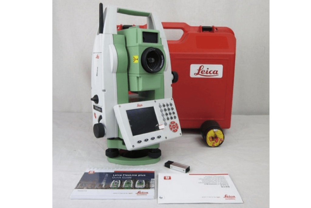
TOTAL STATION
A sophisticated equipment that integrates the functions of a theodolite and an electronic distance measurement (EDM) device.
- Components: Telescope, horizontal circle, vertical circle, levelling mechanisms, EDM.
- Applications: land surveying and topographic mapping, construction layout and alignment, tunnel and bridge engineering, meteorology (used in measuring wind directions), mining operations, archaeological site mapping.
- Magnification: <30X
- Angle Accuracy: 0.5 to 2 arc-seconds, 5arc-seconds.
- Distance accuracy with reflector: +-1mm +1ppm to +-3mm + 2ppm. This means that at 1km error would be at 2-3mm.
- Distance accuracy without reflector: +-2mm +2ppm to +-5mm + 2ppm. This depends on the device.
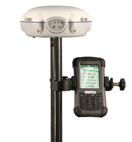
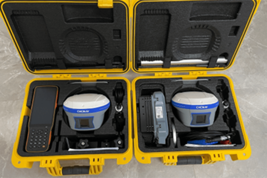
CHC X91 GNSS RECEIVER
Equipment for precise geospatial data collection in various surveying applications. Supports satellite constellation of GPS, GLONASS, SBAS, Galileo.
- Real-time Kinematics (RTK) accuracy: Horizontal = +-(10mm + 1ppm) RMS.
Vertical = +-(20mm+ 1ppm) RMS.
- Post processing (PPK) accuracy: Horizontal = (2.5mm + 0.5ppm) RMS.
Vertical = (5mm+ 0.5ppm) RMS.
- Data formats: RTCM 2.1, RTCM 2.3, RTCM 3.0, CMR, RTCA for input and output. NMEA 0183 outputs. RINEX and HCN outputs for GNSS raw data.
- Battery life: up to 9hrs for static mode and 5hrs in RTK mode.
Applications
- Land surveys
- topographic survey
- mapping projects
- hydrographic surveys
- dredging operations.
CHCNAV i50 GNSS receiver
The CHCNAV i50 GNSS receiver gives speed and accuracy in one easy-to-use GNSS solution to complete your surveying and construction and projects efficiently. Combined with CHCNAV LandStar 7 field software and HCE320 android controller, the i50 is the perfect solution for topographic and construction positioning tasks.
Accuracy (RTK)
- Horizontal: 3mm + 0.5ppm
- Vertical 5mm + 0.5ppm
Accuracy (Static)
- Horizontal: 3mm + 0.5ppm
- Vertical 5mm + 0.5ppm
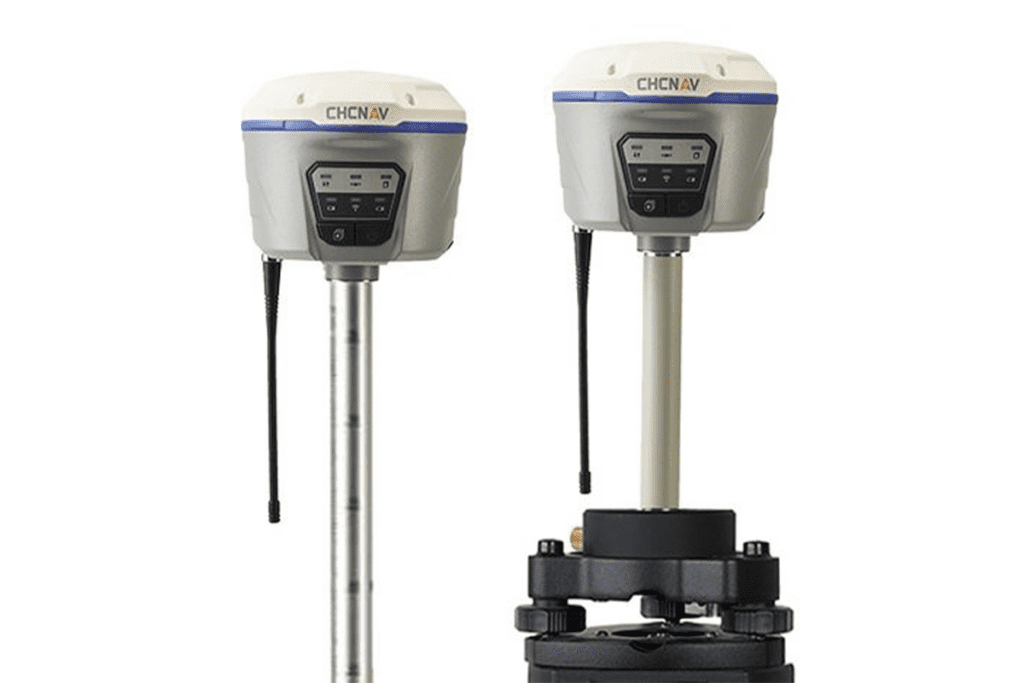
CHCNAV i90 GNSS RECEIVER
High precision GNSS receiver designed for surveying and engineering applications. Satellite constellation of GPS+BDS+Glonass+Galileo+QZSS
Accuracy:
Real time kinematics (RTK)
- Horizontal: 8mm + 1ppm RMS
- Vertical 15mm + 1ppm RMS
Post processing kinematics (PPK)
- Horizontal: 2,5mm + 1ppm RMS
- Vertical 5mm + 1ppm RMS
Post processing static
- Horizontal: 2.5mm + 0.5ppm RMS
- Vertical 5mm + 0.5ppm RMS
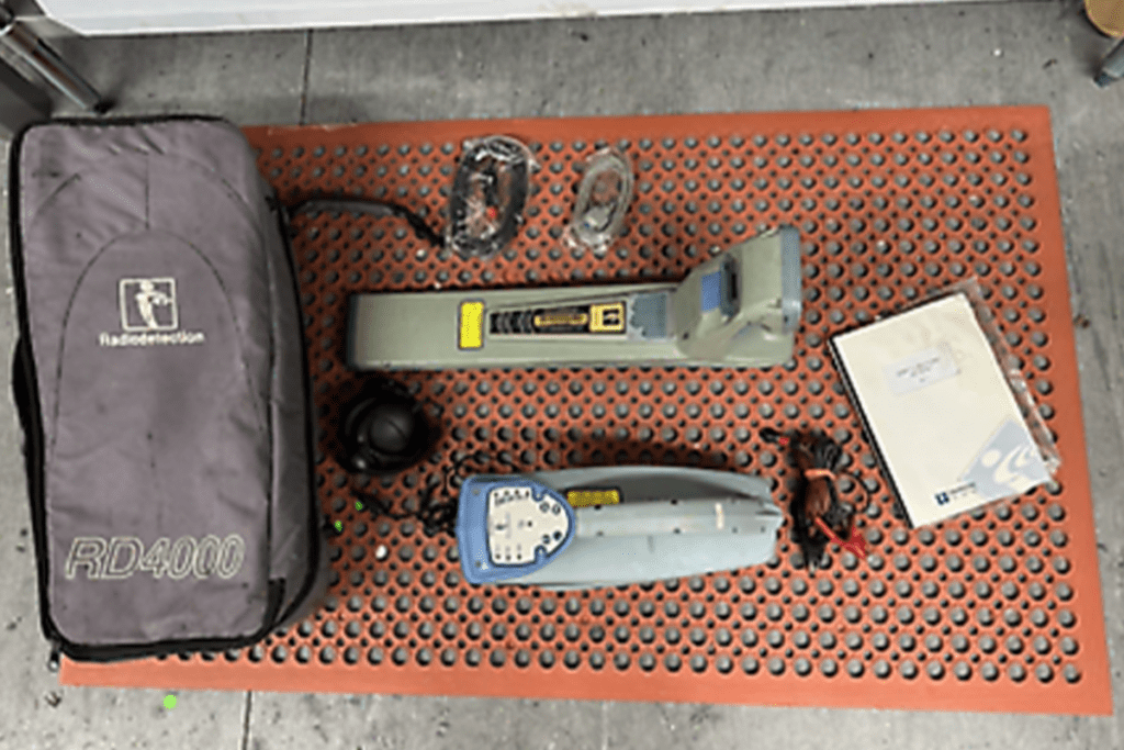
PIPE DETECTOR (radio detection RD4000PL-007)
A pipe or underground utility locator, commonly used in construction, utility maintenance, and surveying applications. Detects buried pipes, cables and other utilities by utilizing electromagnetic signals.
Applications: commonly used by utility companies, contractors and surveyors for tasks as locating water, gas, and electrical lines, as well as other buried infrastructure.
Position Accuracy (Horizontal): within +-10 – 20 cm (approx. 4-8 inches
Depth Accuracy: +-10% of the depth or +-5cm (2inches)
The RD4000PL-007 is more accurate when tracing metallic pipes, as they provide a stronger and more consistent signal. Non-metallic pipes may offer less precise results, and in such cases, the accuracy may decrease, particularly at greater depths.
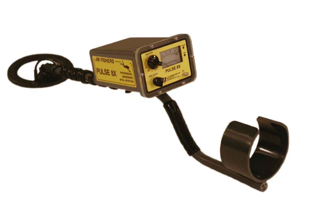
METAL DETECTOR (Jw Fisher Pulse 8x)
Highly regarded as pipe and cable locators. Designed to locate buried utilities such as pipes, cables and other underground infrastructure.
Capabilities
- Advanced pulse induction technology
- Depth measurement
- Multiple frequency options
- Adjustable sensitivity
- Signal indication
- Long battery life
Accuracy
- Position: within 5-10cm (2-4inches), in optimal usage conditions.
- Depth: +-10%. Depends on the pipe or cable type and environmental factors.
Applications
- Utility Locating
- Construction and Excavation
- Surveying and Mapping
- Telecommunication and Electrical work.
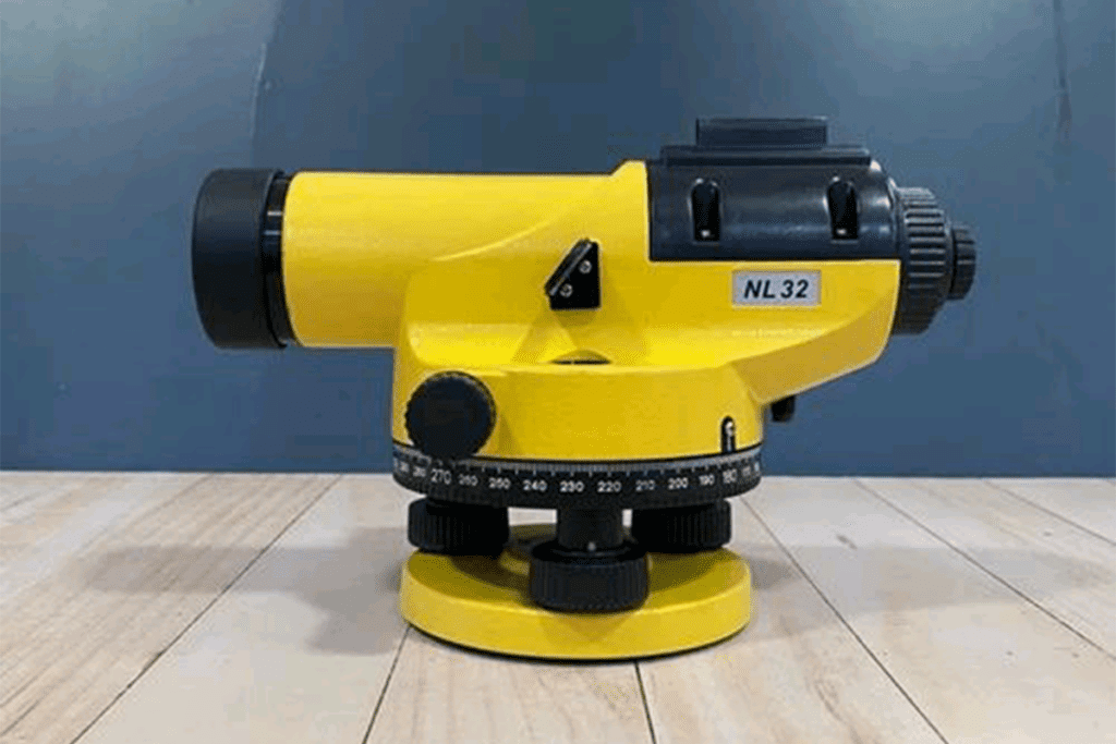
AUTOMATIC LEVEL (self-levelling or dumpy level)
Precision equipment with a telescope and circular bubble, used in surveying and construction to measure or establish a horizontal plane.
Applications
- Construction projects (roads, building, drainage systems).
- Setting foundations
- Checking elevation differences
- Aligning structures
Accuracy: within 1/8 inch (3mm) over a 100-foot (30m) span.
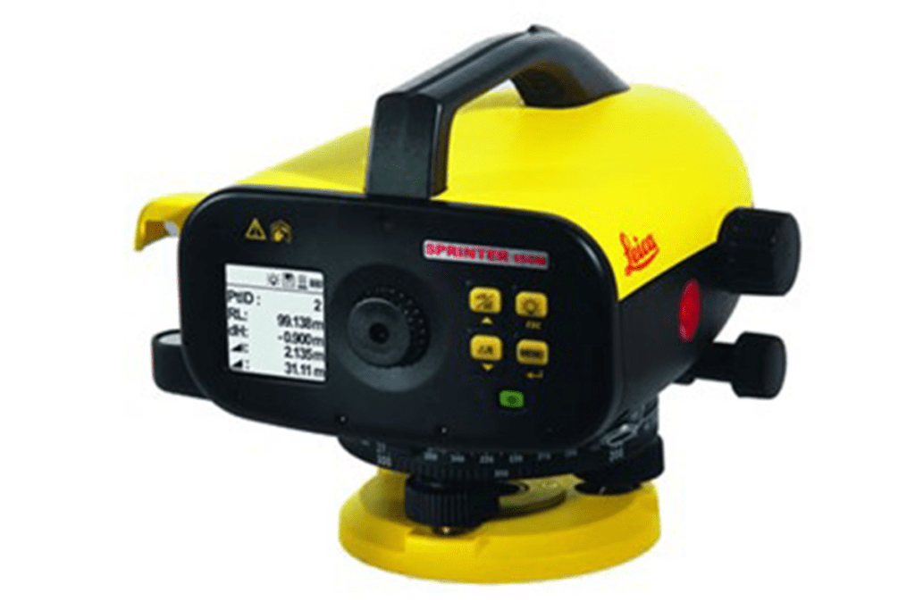
DIGITAL LEVEL
Modern surveying equipment for measuring height differences and distances with high accuracy.
Application
- Construction
- Surveying
- Precision work
Accuracy: 0.1mm/m (+-0.05°)
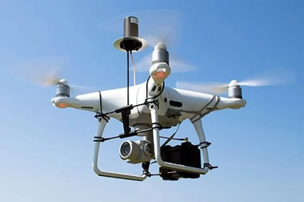
DJI PHANTOM 4 PRO V2.0 WITH LOKI
- Compact & Reliable: The Phantom 4 Pro V2.0 with Loki is a lightweight, easy-to-deploy drone built for professional surveying and engineering projects like construction monitoring, stockpile measurements, land mapping, and general engineering surveys.
- High-Quality Imaging: Equipped with a 20MP mechanical-shutter camera lasting up to 30 minutes of flight time per battery, it captures sharp, distortion-free aerial photos perfect for maps, 3D models, and terrain analysis.
- Accurate & Efficient: With Loki’s precision positioning, every image is georeferenced to survey-grade accuracy maintaining are error of around ±2-3 cm horizontally and ±4-5 cm vertically, reducing the need for extensive ground control points.
- Practical Flight Performance: It has GPS/GLONASS stability, and smooth handling make it reliable in the field.
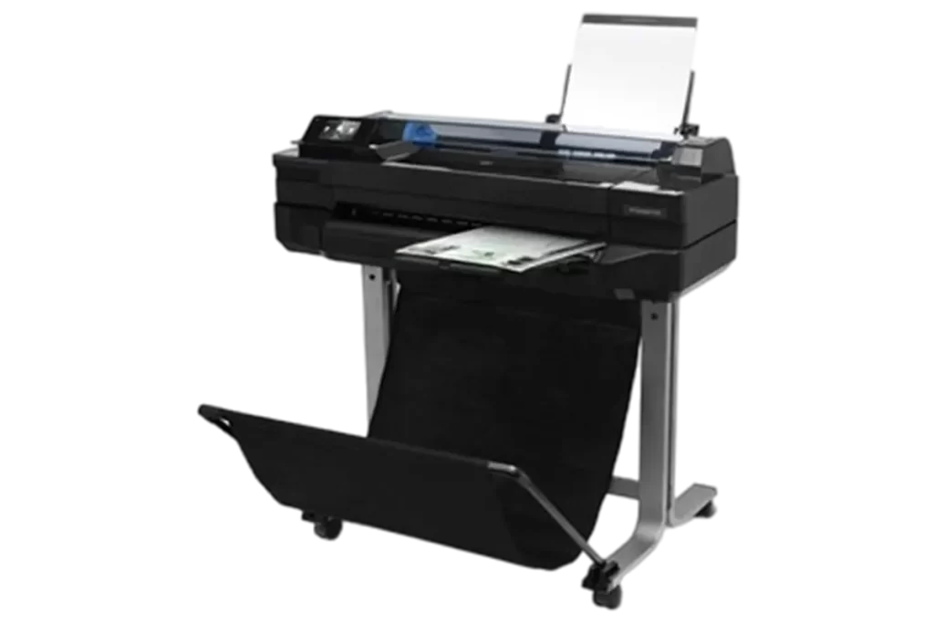
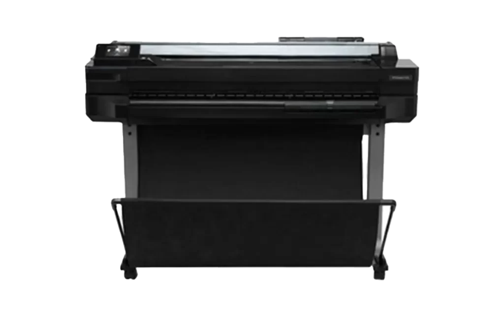
HP DesignJet T520 Large-Format Inkjet Printer
With a fairly compact design and built-in Wi-Fi connectivity, the DesignJet T520 Inkjet Printer from HP makes it easy to create large-format images in your home or office. Optimized HP Thermal Inkjet technology helps provide a 2400 x 1200 dpi optimized resolution for both black and color, allowing the unit to create detailed documents and graphics.
Capabilities:
- Max Resolution: 2400 x 1200 dpi
- Printable Width: Up to 36″
- Print Speed: 35 Sec/Page (A1 Size)
- HP Thermal Inkjet Technology
- Mobile Printing for iOS and Android
- Front-Loading Roll Feed
- Manual Sheet Feed and Input Tray
- Touchscreen LCD and Automatic Cutter
- USB 2.0, Ethernet & Wi-Fi Connectivity
Applications
Applications such as:
- Technical Drawings: Create precise lines and sharp details for architectural blueprints, engineering designs, and CAD drawings.
- Mapping & GIS: Print detailed maps for various purposes.
- Photography: Produce high-quality photos on various photographic media.
- Presentations: Deliver professional-looking presentations and posters with excellent color accuracy and detail.
- Marketing Materials: Print posters, banners, and other promotional materials for events or businesses.
Accuracy:
- Line Accuracy: The printer has a stated line accuracy of ±0.1% and can produce lines as thin as 0.07 mm, which is crucial for technical drawings and detailed prints.
- High Resolution: It offers an optimized print quality of up to 2400 x 1200 dpi, ensuring sharp details and fine text.
Working With The Best
Our OEMs


An integrated geospatial company focused on client satisfaction and professional excellence.